In the heart of Indiana, researchers at Purdue University are revolutionizing the way we understand and manage our forests. H. Hanafy, a lead author from the Lyles School of Civil and Construction Engineering, has developed a groundbreaking framework that combines data from Unmanned Aerial Vehicles (UAVs) and BackPack LiDAR systems to create a detailed, fine-scale forest inventory. This isn’t just about counting trees; it’s about understanding their structure, health, and potential for sustainable management.
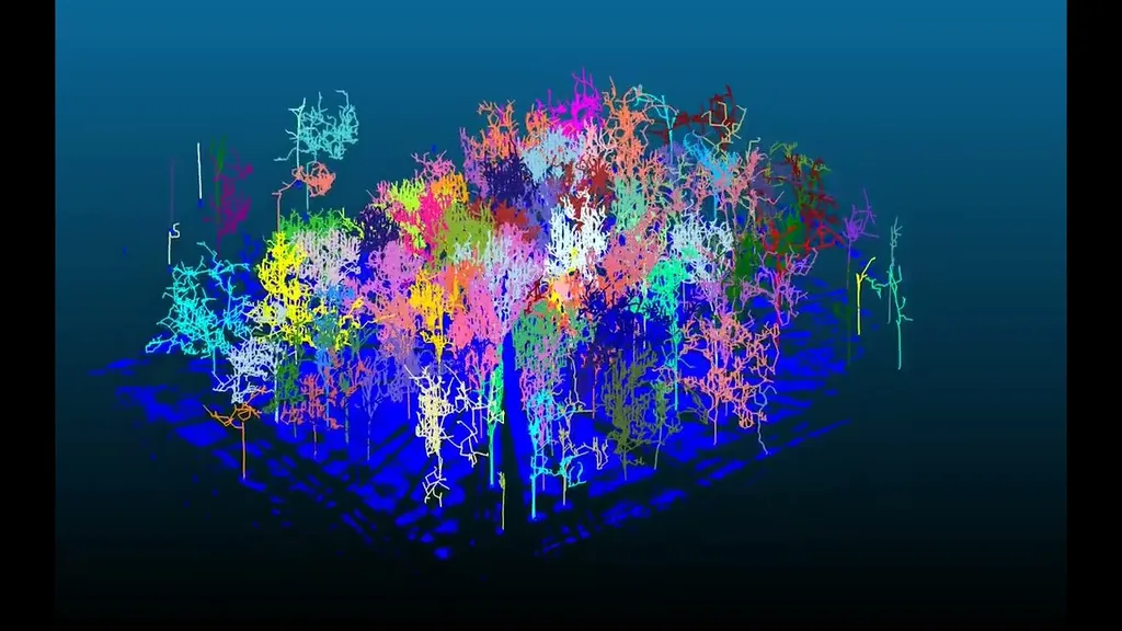
The technology uses Light Detection and Ranging (LiDAR) to capture detailed point clouds of forest canopies, providing a 3D map of the forest structure. “We’re not just looking at the forest from above; we’re diving into the details,” Hanafy explains. “This technology allows us to see the forest in a way we’ve never seen before, down to the individual trees and their specific attributes.”
The framework processes multi-resolution LiDAR data to extract key forest attributes like tree location, height, and diameter at breast height (DBH). The methodology involves a multi-stage processing pipeline that includes adaptive ground removal, intensity/geometry-based filtering for woody part separation, and layered density-based spatial clustering. This ensures accurate tree segmentation and biometrics estimation, even in dense forest environments.
One of the most exciting aspects of this research is its potential for tree species identification. By linking LiDAR data with imagery captured by UAVs and BackPack systems, the framework can associate segmented trees with specific species. This opens up new possibilities for ecological assessment, biomass estimation, and sustainable forest management.
The implications for the energy sector are significant. Accurate forest inventory is critical for biomass estimation, which is a key factor in renewable energy production. “This technology can help us manage our forests more sustainably, ensuring that we have a reliable source of biomass for energy production,” Hanafy says.
The research, published in ‘The International Archives of the Photogrammetry, Remote Sensing and Spatial Information Sciences’ (translated to English as ‘The International Archives of the Photogrammetry, Remote Sensing and Spatial Information Sciences’), demonstrates an F1-score of 100% for tree detection and a 3.1 cm root mean square error (RMSE) for DBH estimation. These results highlight the reliability of the proposed framework for accurately detecting trees and estimating their DBH.
Looking ahead, Hanafy and his team plan to improve tree segmentation in complex forest environments and leverage machine learning models for automated species classification. This could lead to even more accurate and efficient forest inventory processes, benefiting not just the energy sector, but also ecological assessment and conservation efforts.
As we face the challenges of climate change and the need for sustainable energy sources, this research offers a scalable solution for large-scale forest monitoring. It’s a step towards a future where we can manage our forests more effectively, ensuring their health and productivity for generations to come.