In the heart of bustling cities, where every second counts during emergencies, a groundbreaking approach to deploying Unmanned Aerial Vehicles (UAVs) is set to revolutionize disaster management. Researchers, led by Z. Wu from the School of Civil Engineering and Transportation at South China University of Technology, have developed a 3D voxel-based collaborative path planning framework that promises to optimize UAV operations in urban environments. This innovation, published in ‘The International Archives of the Photogrammetry, Remote Sensing and Spatial Information Sciences’ (known in English as ‘The International Archives of Photogrammetry, Remote Sensing and Spatial Information Sciences’), could have significant implications for the energy sector, particularly in enhancing the efficiency of emergency response and maintenance operations.
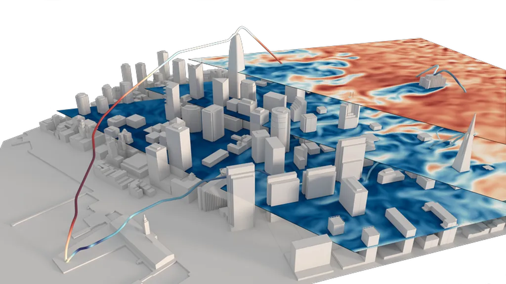
The study addresses a critical challenge in urban emergency response: the efficient deployment of UAVs for timely and effective disaster management. By transforming traditional triangular mesh data into a voxel-based map, the researchers have created a more efficient system for UAV navigation. “The voxel-based approach simplifies the complexity of urban environments, making it easier for UAVs to navigate and complete tasks quickly,” explains Wu.
The framework consists of three key components: navigation map construction, local coverage path planning, and global coverage path planning. For local coverage, the researchers introduced an improved Boustrophedon Cell Decomposition (BCD) algorithm, specifically tailored for UAV operations. Global coverage is addressed through a multi-traveling salesman problem (MTSP) approach, optimized using the Jump Point Search (JPS) algorithm and Genetic Algorithm (GA).
The results are impressive. Compared to the conventional A* algorithm, the new framework decreases the total route length by 23.80% and improves path smoothness. This enhancement in efficiency and coverage could be a game-changer for the energy sector, particularly in scenarios requiring rapid response and comprehensive area coverage, such as inspecting power lines after a storm or assessing damage in an industrial accident.
The potential applications extend beyond emergency response. In the energy sector, UAVs equipped with this technology could be used for routine inspections of infrastructure, such as power lines, wind turbines, and pipelines. The ability to cover large areas quickly and efficiently could lead to significant cost savings and improved safety.
“This research provides a robust foundation for multi-UAV collaborative operations in urban environments,” Wu notes. “It offers improvements in efficiency and coverage that could be crucial in various applications, including emergency response and infrastructure maintenance.”
As the energy sector continues to evolve, the integration of advanced technologies like this voxel-based path planning framework could play a pivotal role in enhancing operational efficiency and safety. The research not only advances the field of UAV navigation but also opens up new possibilities for the energy sector, paving the way for more effective and efficient disaster management and infrastructure maintenance.