In the heart of Northeast Mexico, where the skies are vast and the rains increasingly unpredictable, a new approach to dam construction is taking flight—literally. Researchers led by A. Vega Aguilar from the Faculty of Civil Engineering at the Universidad Autónoma de Nuevo León are harnessing the power of Unmanned Aerial Vehicles (UAVs) to revolutionize flood risk assessment, offering a glimpse into how technology can reshape the energy sector’s approach to infrastructure development.
Traditionally, dam construction in flood-prone regions has relied on ground-based surveys and limited hydrological data to assess environmental risks. While these methods meet legal requirements, they often fall short in providing the spatial detail and rapid updates needed for robust risk modeling. Enter UAVs, equipped with LiDAR and high-resolution imaging capabilities, which are transforming how engineers and planners approach these critical projects.
“UAVs provide a level of detail and flexibility that ground-based surveys simply can’t match,” Vega Aguilar explains. “We can capture high-resolution data over large, complex terrains quickly and efficiently, which is crucial for accurate flood modeling and environmental monitoring.”
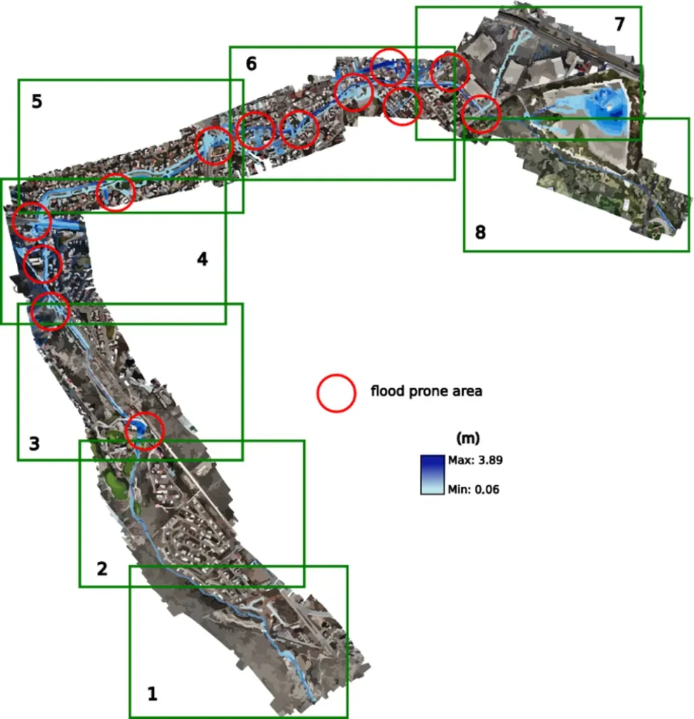
The study, published in the ISPRS Annals of the Photogrammetry, Remote Sensing and Spatial Information Sciences (which translates to the Annals of Photogrammetry, Remote Sensing and Spatial Information Sciences), focuses on a dam project in Northeast Mexico, a region grappling with increasing rainfall variability and extreme weather events. By integrating UAV-based data, the researchers were able to assess flood risks more precisely, incorporating return period scenarios and quantifying the impact on trees and infrastructure.
This approach not only enhances the accuracy of environmental impact assessments but also supports better decision-making in dam planning and operation. For the energy sector, the implications are significant. As the demand for renewable energy sources grows, so does the need for reliable infrastructure to support them. Dams, in particular, play a crucial role in hydroelectric power generation, and ensuring their resilience against flooding is paramount.
“By leveraging UAV technology, we can mitigate risks more effectively and protect both the ecological and operational integrity of these projects,” Vega Aguilar adds. “This is not just about meeting regulatory requirements; it’s about building smarter, more sustainable infrastructure.”
The research highlights the potential for UAVs to become a standard tool in the energy sector’s arsenal, offering a cost-effective and efficient way to gather critical data. As climate change continues to intensify weather patterns, the ability to adapt and innovate will be key to ensuring the resilience of our infrastructure.
In the broader context, this study underscores the importance of integrating advanced technologies into traditional practices. By doing so, the energy sector can not only enhance its operational capabilities but also contribute to a more sustainable future. As Vega Aguilar and his team continue to push the boundaries of what’s possible, one thing is clear: the future of dam construction is taking flight, and the sky’s the limit.